GPS Navigation App - Offline
Posted: Mon Oct 22, 2018 2:53 am
Dear Fellow Almoster,
I have been contemplating about buying a new GPS system for months now and after reading a lot about all the options available in the market and asking as many Marshals, Advance, Intermediates, Crews, Newbies, pretty much anyone who has a GPS I came to the conclusion that the GPS of choice for many is the GARMIN MONTANA 610 with all the bird's eye view features and track recording and all that.
So upon research I also found that this device does not come cheap, then again why would it be ? this thing is LOADED with features. This is a MUST HAVE device for anyone serious about off-roading and is well worth the price, in fact if you ask any of the senior members about the value of their Garmin and they will most probably say that its one of the most invaluable piece of equipment they have.
But it costs around AED 2000/-. Hence, apps to the rescue!!!.
After trying multiple apps which failed miserably and did not even come remotely close to function as perfectly as the Montana 610. I came across this one application which just might do the job for others like me who cannot spend that kind of money right away and have to save up or wait for sometime to get their hands on a Montana 610.
AGAIN, THIS IS NOT A REPLACEMENT TO THE GARMIN MONTANA 610. THIS IS JUST ME USING THIS APP UNTIL I GET MYSELF A PROPER GPS TRACKING DEVICE and telling everyone what I discovered and how my experience has been with this app so far.
So first things first, the application name isAll-In-One Offline Maps by Psyberia Ltd. and it comes in two different variants with one being free and the other being paid (AED 9.99/-).
You can read all the technical information about them and their features on these links :
I just wanted an app that can be just as accurate as these fancy Garmins and help me in navigate while driving offroad but also have very detailed quality bird's eye view. If it can trace my tracks and save them then it would be a bonus but I dont need that at the moment since i don't really go that deep into the desert or even if I do then I always stay on the commonly used tracks and I don't really see myself leading any kind of drives or convoys in the near future.
Any how so this is what the logo looks like :

Now, this app has a bit of a learning curve to it and takes quite some time to understand how it works, I am still figuring out how to make it trace my tracks and log them or save them.
Still it serves my purpose of being my GPS guidance device without breaking the bank and it does all and even more than the following points listed:
So as per my current list of GPS requirements to which I don't really see anything more adding up in the near future, this app pretty much does all that is required for me or any other newbie out there without spending any money on the Garmins grin .
THIS APP WILL USE DATA SUPER FAST
So before you do anything, switch off the online maps by doing this:
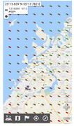
This will stop the app from burning through your data package by not freshly downloading any new section of the map which was not downloaded before. Also it will show you all the layers of zoom level coverage of every area stored on your phone. Green means stored on phone and Red means NOT stored on phone
To make the app store all the map data in the memory card of the phone please follow the following steps:
Now the app will store all of its data in the SD Card and leave your phone memory alone.
The fun part starts now, I am sure you all have other navigation apps on your phone to help you on the roads. As do I, so I just deleted all of the road maps use only the Google Satellite map for the bird's eye view. You can do this using the following steps:
You should see all the different Google Maps in your list of Available Maps
Now to search for places or even put in direct coordinates, its quite simple. Just follow these step.
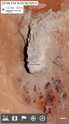
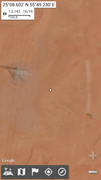
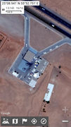
Now here is a sample of a few fully zoomed in pictures of Fossil Rock area and the petrol pump where we usually go for inflating
Fossil Rock
Point of crossing over the rocks
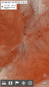
Power cable line/track
Petrol pump after Fossil Rock
To search for coordinate simple repeat this process but instead of searching by Location Name search by Lat/Long (Deg) or Lat/Long (Deg Min) or even by Lat/Long (Deg Min Sec) depending upon the format of the given coordinate that you are searching for.
Enter your the coordinates you are looking for and it stores in the memory for all future references until you delete it manually. So for example if you have multiple coordinates you can search for all of them and it will store them and you can also individually name all these coordinates like Waypoint 1, Waypoint 2 etc.
Now if you want to save a an area of the map for offline usage then follow these simple steps:
Now the app will download that area so you can use it offline.
So there you have it, you got you super accurate GPS device and super detailed bird's eye view and it didn't cost you thousands of dirhams.
Enjoy.
I have been contemplating about buying a new GPS system for months now and after reading a lot about all the options available in the market and asking as many Marshals, Advance, Intermediates, Crews, Newbies, pretty much anyone who has a GPS I came to the conclusion that the GPS of choice for many is the GARMIN MONTANA 610 with all the bird's eye view features and track recording and all that.
So upon research I also found that this device does not come cheap, then again why would it be ? this thing is LOADED with features. This is a MUST HAVE device for anyone serious about off-roading and is well worth the price, in fact if you ask any of the senior members about the value of their Garmin and they will most probably say that its one of the most invaluable piece of equipment they have.
But it costs around AED 2000/-. Hence, apps to the rescue!!!.
After trying multiple apps which failed miserably and did not even come remotely close to function as perfectly as the Montana 610. I came across this one application which just might do the job for others like me who cannot spend that kind of money right away and have to save up or wait for sometime to get their hands on a Montana 610.
AGAIN, THIS IS NOT A REPLACEMENT TO THE GARMIN MONTANA 610. THIS IS JUST ME USING THIS APP UNTIL I GET MYSELF A PROPER GPS TRACKING DEVICE and telling everyone what I discovered and how my experience has been with this app so far.
So first things first, the application name isAll-In-One Offline Maps by Psyberia Ltd. and it comes in two different variants with one being free and the other being paid (AED 9.99/-).
You can read all the technical information about them and their features on these links :
- All-In-One Offline Maps (Free)
- All-In-One Offline Maps+ (Paid)
I just wanted an app that can be just as accurate as these fancy Garmins and help me in navigate while driving offroad but also have very detailed quality bird's eye view. If it can trace my tracks and save them then it would be a bonus but I dont need that at the moment since i don't really go that deep into the desert or even if I do then I always stay on the commonly used tracks and I don't really see myself leading any kind of drives or convoys in the near future.
Any how so this is what the logo looks like :
Now, this app has a bit of a learning curve to it and takes quite some time to understand how it works, I am still figuring out how to make it trace my tracks and log them or save them.
Still it serves my purpose of being my GPS guidance device without breaking the bank and it does all and even more than the following points listed:
- Garmin quality accurate coordinate pin pointing
- Tracks my exact location using multiple satellites and is extremely accurate
- Allows you to download multiple map data area wise (google maps or any other maps)
- The multiple map data can be of terrain type, satellite imagery type, road map type
- Allows you to use it without any data package
- Allows you to search for locations by Name, Point of Interest and even Coordinates
- Allows you to enter, search and save multiple coordinates in all their writing formats
- Allows you to give your saved coordinates custom names.
- Traces my tracks/drive while offroading but stops and starts tracing again with a fresh track from the current point every time I lock the phone and turn it back on (I am sure there is something I am missing here)
- Don't know if it saves my tracks anywhere or not (still haven't looked into this)
So as per my current list of GPS requirements to which I don't really see anything more adding up in the near future, this app pretty much does all that is required for me or any other newbie out there without spending any money on the Garmins grin .
THIS APP WILL USE DATA SUPER FAST
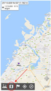
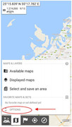
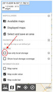
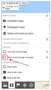
So before you do anything, switch off the online maps by doing this:
- Start the app and tap the MAPS & LAYERS button
- tap the OPTIONS button
- Check the Use only local storage box
- You can also check the Show local storage coverage
This will stop the app from burning through your data package by not freshly downloading any new section of the map which was not downloaded before. Also it will show you all the layers of zoom level coverage of every area stored on your phone. Green means stored on phone and Red means NOT stored on phone
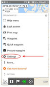
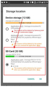
To make the app store all the map data in the memory card of the phone please follow the following steps:
- Tap the Map icon on the lower left corner of the screen
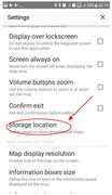
- Tap the Settings button
- Tap the Storage Location
- Choose SD Card
Now the app will store all of its data in the SD Card and leave your phone memory alone.
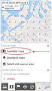
The fun part starts now, I am sure you all have other navigation apps on your phone to help you on the roads. As do I, so I just deleted all of the road maps use only the Google Satellite map for the bird's eye view. You can do this using the following steps:
- Tap the MAPS & LAYERS button
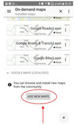
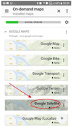
- Tap the Available maps button
- You will see a list of available maps on your phone. If you don't see any Google Maps then scroll down and tap theADD NEW MAPS button
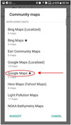
- Tap the Google Maps button
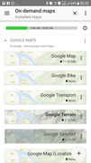
You should see all the different Google Maps in your list of Available Maps
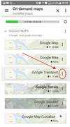
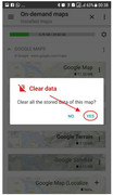
- Now delete all the of the map data within all those different type of maps in the list so you have enough space when you want to store the Google Satellite Map data by tapping the 3 dotted line next to the map names
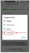
- Tap the Clear data button
- Tap the Yes button to confirm
- Now Rinse and repeat for all the maps grin
- Now tap the Google Satellite button
- Now the screen should look like this and we are ready to rock and roll
Now to search for places or even put in direct coordinates, its quite simple. Just follow these step.
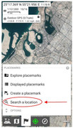
- Tap the Placemarks button
- Tap the Search a location button
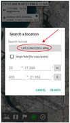
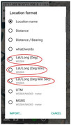
- Tap the Search Format button
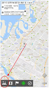
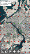
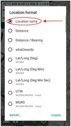
- Now choose the format of your search parameters for example I searched for Fossil Rock by selecting the Location name option
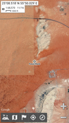
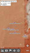
- Then typed in Fossil Rock in the search box. After selecting the result this is what showed up
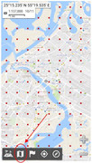
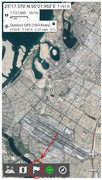
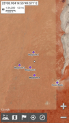
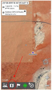
Now here is a sample of a few fully zoomed in pictures of Fossil Rock area and the petrol pump where we usually go for inflating
Fossil Rock
Point of crossing over the rocks
Power cable line/track
Petrol pump after Fossil Rock
To search for coordinate simple repeat this process but instead of searching by Location Name search by Lat/Long (Deg) or Lat/Long (Deg Min) or even by Lat/Long (Deg Min Sec) depending upon the format of the given coordinate that you are searching for.
Enter your the coordinates you are looking for and it stores in the memory for all future references until you delete it manually. So for example if you have multiple coordinates you can search for all of them and it will store them and you can also individually name all these coordinates like Waypoint 1, Waypoint 2 etc.
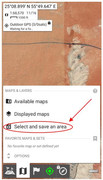
Now if you want to save a an area of the map for offline usage then follow these simple steps:
- Tap the MAPS & LAYERS button
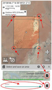
- Tap the Select and save an area button
- Now the app will give you an area to choose, select the area by zooming in and out or by changing the size of the box. Then on the lower part of the screen there is another zoom option with a green scroll bar this gives you the option to choos the level of zoomed in detail you want so the higher the better, drag it all the way to full and tap the play button.
Now the app will download that area so you can use it offline.
So there you have it, you got you super accurate GPS device and super detailed bird's eye view and it didn't cost you thousands of dirhams.
Enjoy.